
STAR-GAZER
This article deals with David Thompson who is the subject for one of the interpretive panels I developed for the Castlegar Millennium Walkway. It focuses on the five year period when Thompson was mandated by the partners of the North West Company to establish a fur trading enterprise west of the Rocky Mountains. His work formed the foundation for a successful industry which passed into the hands of the Hudson's Bay Company, for whom he had once worked. In addition to his primary responsibility of trading with the natives, Thompson explored the vast Columbia watershed and produced amazingly accurate maps. In his later life, he tried to have them published without success, although other cartographers used his information without giving him any credit. For all his dedication to exploration and discovery, there is hardly a feature to be found along the waterways he followed which bears his name.June 22, 1807. On the first day of summer, Thompson is finally standing in the snow-bound pass which he will later name after Joseph Howse. He is looking at the steeply descending valley of the stream (Blaeberry River) which he must follow through the unknown mountains to get to the valley where the elusive Columbia River may provide an easy route to the Pacific. Eight days later, the company which includes eight men, several horses, as well as Thompson's wife Charlotte and children reaches a river which flows in a northerly direction. As the Columbia should be flowing south, he calls it the Kootanae and decides to follow it upstream. After many days of grueling work punctuated by near starvation, they reach a lake (Lake Windermere) where they decide to construct a post. After starting work, Thompson is convinced by Kootenay Indians that its location is poor and they find a more suitable site near the mouth of Toby Creek. Here he builds Kootanae House, where they spend their first winter in never-ending apprehension about the Piegan Indians who are enemies of the Kootenay Indians and do not wish to see them armed by the newcomers. Before the onset of winter, Thompson is guided by the Kootenay chief to another river which Thompson knows as McGillivray's River (today's Kootenay) at whose lower reaches the main Kootenay encampment is located.
In the spring of the following year the first load of furs is sent east by retracing their route across the mountains, and new supplies are brought in. In May, the company once again sets south to follow McGillivray's River to the Kootenay encampment, and if possible, to the large lake into which he has been told it drains. He also knows that from this lake, the river flows westward, and after a final turbulent stretch, meets a larger river that must be the Columbia. They reach the Kootenay camp and proceed further, reaching the lower end of Kootenay Lake on May 14th . Disaster quickly follows. Flood waters inundate the countryside and threaten his return route upstream. Even worse, the meeting with the new tribes (Salish) which he had arranged is no longer possible as the flooding impedes their travel. Thus, he laments, "All my fine hopes are ruined." Their return to Kootanae House is fraught with danger as in order to avoid fighting their way up the ravaging McGillivray's River, they follow the rugged native overland trail which follows the Moyie River. They return on June 6th and immediately commence to haul the next fur shipment out. After returning on November 10th 1808, the group prepares to spend the second winter at the lonely outpost.
By now, Thompson has decided that he has located his headquarters in the wrong place. The countryside is too dry to support a large beaver population and in late summer and fall the absence of game leads the inhabitants to near starvation. Even worse is the remote location, exposed to the frequent visits of the unfriendly Piegans. He decides to build new outposts to the south in the "Lake Country" which he has only tentatively explored. It promises to be far better for trade and the presence of friendly natives will offer protection.
At the back of his mind is always the great waterway to the sea - the Columbia. As far as he knows, he has not seen the river yet, but he knows it is somewhere to the west, running in a generally south-westward direction. He knows McGillivray's River runs into it. But where is the Columbia's source? And where does his Kootanae River end as it pursues its northerly course? Perhaps next year he will find the answers.
After returning from the routine trip across the mountains in August of the following year, Thompson decides to carry out his plan to set up new outposts in the more promising country to the south. He follows the native overland trail from the Kootenay encampment near present-day Bonners Ferry to the Pend d'Oreille River, which he names the Saleesh. On the shore of Pend d'Oreille Lake they construct the first new post which he names Kullyspel House. In November he builds a second outpost on the upper reaches of Saleesh River (today's Clark Fork) which he aptly names Saleesh House. A third post called Spokane House is to be built by Jaco Finlay for the Company next summer.
In early spring of the following year (1810) Thompson decides to explore the lower reaches of the Pend d'Oreille River. He is told by his guides that the last stretches of the river are not navigable; however they follow the river to the vicinity of Metaline Falls. Abandoning their boats, the party clambers up one of the adjacent mountain peaks. Here Thompson gazes over the vast sea of mountains and realizes for the first time that he is standing between two vast valleys which must run together far to the north. The central island of mountains which he calls Nelson's Mountains is circumscribed by the valleys. "I now perceived the Columbia River was in a deep valley at the north end of these rude hills, and its west side the high rolling lands of Mount Nelson, round which it runs." Now he suspects he has been on the Columbia all along: the Kootanae River is only its northward running branch, and his Kootanae House is very close to the actual source of the great and mysterious river. Fate was going to propel him to the site where the two vast valleys converge, and within a year and a half he would follow and map every foot of the Great River.
Thompson was intending to spend the balance of the year back in civilization and was returning with his wife and children along with the routine fur shipment. At Rainy River, he was given instructions to turn back and follow the Columbia to the Pacific. He attempted to cross the Rockies - as so many times before - over Howse Pass. This time, however, the Piegans were waiting for him and he was forced to retreat from this familiar ground. He decided to seek out another native pass far to the north, at the headwaters of the Athabasca River. Delays associated with these changes put him in the high mountains far too late in the season. Thompson, however, was undaunted and pushed on into the heavy snows with a crew that was quickly losing enthusiasm for the venture. On January 10th 1811 he found himself in the "dreadful desolation" of Athabasca Pass. "Many reflections came on my mind; a new world was in a manner before me, and my object was to be at the Pacific Ocean before the month of August. How were we to find provisions, and how many men would remain with me, for they were dispirited? Amidst various thoughts I fell asleep on my bed of snow."
On the steep descent along his Flat Heart River (Wood River), Thompson is awestruck by the huge trees : "on the east side we were men among the trees ; here we were pygmies." In a few days they reach what he still calls the Kootanae River at the strategic spot he imagined from his mountaintop near Metaline Falls - where the two valleys meet. His plan to follow the river downstream falls apart when five of his men desert him. With only two men left, there is no choice remaining. They clear a 10 foot square off snow and with split cedar build a small shelter where they spend the rest of the winter. Then they construct a small canoe from split cedar which is stitched together with spruce roots.
In the spring they leave Boat Encampment, choosing to go the familiar route upstream, past the deserted Kootanae House and down McGillivray's River to the Indian encampment. Here they take the overland trail and organize a new expeditionary force from the men at the posts and native guides. At Kettle Falls new canoes are built and on July 3rd Thompson sets off downstream to the sea. He arrives at his destination on July 15th, finding John Jacob Astor's trading post well established near the mouth of the river. After a short stay, the Thompson party returns upstream, reaching Fort Spokane via Snake River and an overland route.
There is not much time to waste. The season is advancing and Thompson wants to test the new route for shipping out furs and bringing in supplies. In late August they leave Kettle Falls, and by noon of September 5th, they reach the mouth of McGillivray's River which Thompson follows a short distance upstream. He spends the night, probably near the junction of the rivers. The following day, the men work their way up the Tin-Cup Rapids and soon find themselves in the easy water of Lower Arrow Lake. That evening Thompson is surprised to see a bright comet in the sky. When he reaches the little hut at Boat Encampment again on Sept. 18th , he has to wait several days for supplies to arrive across the mountains. He ventures up the Canoe River to check its course. This final exploration convinces him that his hunch was right : from its source close to McGillivray's River (near Canal Flats), the Columbia runs north until it makes a big bend southward where the Canoe River enters it. He has now seen all of it and he is convinced that he has found a practical route across the continent.
With new supplies, he turns back and reaches Kettle Falls on October 30th. Finding the camp deserted, he walks the 70 miles to Spokane House in three days. Finally, with winter setting in, he travels to Saleesh House which he finds vandalized by the Piegans. The men repair the outpost and there spend the winter. His final explorations take him eastward along the Clark Fork River toward the continental divide. In the spring of 1812, he follows the Columbia upstream for the last time.
The failure of Thompson to claim the mouth of the Columbia for the British did not in the end prevent the North West Company from becoming entrenched in the area. In 1812, war broke out between Britain and America and Astor's lonely outpost was doomed. In the following year the Astor enterprise was sold to the Northwesters and many of the employees stayed on to work for the new company. Astoria was renamed Fort George which became the operational headquarters for the Columbia Division until Fort Vancouver replaced it after the company amalgamated with the Hudson's Bay Company in 1821. Thompson's route over Athabasca Pass turned out to be impractical for fur transport. It appears that his return journey in 1812 was the last regular shipment of furs over the pass. In 1814, furs collected the previous year as well as the inventory purchased from the Astor group were sent by ship from Fort George to China. From then on, furs from the Columbia Department were exported via the outlet on the Pacific, and supplies were brought in the same way. There may have been an occasional shipment over the difficult pass when problems developed with the supply ships. The Columbia River remained as the communication lifeline as company records and mail were carried across the continent twice a year by the Express brigades. A standard feature of the autumn Express was a shipment of select river otter furs westward for eventual delivery to Sitka as a partial payment for a leasing agreement with The Russia Fur Company. Accompanying these regular spring and autumn brigades were often paying passengers, some of whom became famous : David Douglas, Paul Kane, Father de Smet, and others.
The remainder of Thompson's life revolved around his ever-growing family and - of course - synthesizing the vast amount of information into very accurate maps. The maps earned him little financial gain and little fame. Late in life, he turned to writing his Journals which were never published during his lifetime. The funds he had acquired as an active partner of the North West Company eventually ran out and Thompson was compelled to sell map originals and his instruments to get by. His eyesight started failing him, from too many night-time calculations by dim candlelight, he claimed. He was distraught at seeing all his work come to naught : the best and most productive lands which he had laid a claim to were given away to the Americans; his maps were used by others for profit and fame; and he was looked on as an eccentric or a curiosity. He thought all his work would be lost and forgotten. And it very nearly was.
David Thompson died in 1857; his faithful wife and traveling companion followed him three months later. Both were buried in an inconspicuous grave at Mount Royal Cemetery in Montreal. After the turn of the century, his amazingly accurate maps caught the eye of J.B.Tyrell who was soon enveloped by the Thompson mystique and with great dedication spent a good deal of the rest of his life making amends for the neglect of others. He traced his manuscripts and journals and arranged Thompson's Travels for publication. As a final gesture, he erected a modest monument on his grave.
During his lifetime David Thompson is reputed to have traveled in excess of 80,000 miles, often through lands previously explored only by the natives. He was a keen recorder of native ways and a meticulous surveyor and map maker. His journals reveal very little of his personality and his wife and children who at times accompanied him remain in the background. He mentions his children only in rare instances when some accident was threatening their fragile lives. In spite of his modesty and his doubts about the perseverance of his work, he left an indelible impression on Canada. And with the adoption of the Columbia River as a part of the transcontinental highway he in a way found that elusive North-West Passage between the oceans which, although it did not follow the ice-choked Arctic Ocean, allowed commerce to flow across the continent. Even though freight shipment along this difficult route was abandoned in a few years, mail service was maintained twice a year by the express brigades for the next four decades.
 |
|
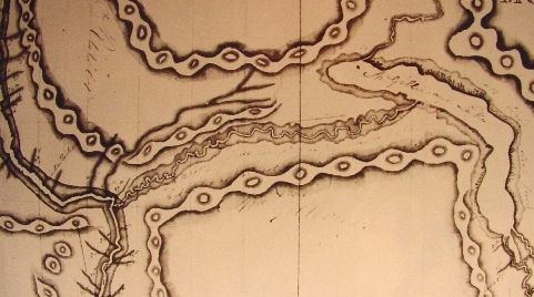
Detail of the local area, from "Map of North
America from 100o West to the Pacific Ocean" (1816) Used by premission of the Public Records Office, London, England. (PRO. # FO 925/4622) |
The David Thompson interpretive panel contains the following text.
STAR - GAZER
For five years David Thompson had been traveling along the Columbia watershed and setting up posts for the North West Company. His meticulous observations enabled him to produce accurate maps of the vast territory he had explored and his frequent use of the sextant won him the name of Koo-Koo-Sint (star - gazer). In 1811 he made the unsuccessful push to extend the Company territory along the Lower Columbia, only to find Astor's outpost already established at the river's mouth. In returning upriver, he for the first time followed the stretch of water from Kettle Falls to Boat Encampment, thus completing his exploration of the river's complex and tortuous course around the mountain barriers. He returned downstream again with fresh provisions to spend the winter at Saleesh House and in the following spring passed our community for the third time, on his way back to civilization, never to return to the Columbia. In doing so, he pioneered a route across the continent which was to be used for nearly half a century.
It is remarkable that Thompson was able to document such a wealth of new discoveries when his main objective was to establish a viable trading enterprise west of the Rocky Mountains. Although he could not interest commercial publishers in his maps, his data was used by other cartographers without credit. The loss - to the Americans - of the territory where he had so successfully established the foundation for the Columbia Department, was a heavy blow. He died in poverty in 1857, reduced to selling his maps and instruments to support his family.
By mid-day of September 5th 1811 Thompson reached the mouth of McGillivray's (Kootenay) River, which he tentatively explored. He was met by a group of natives with gifts of fresh salmon and berries, and the party spent the night in this vicinity. Early the following morning, the party sets off and Thompson comments on local features: Tin Cup Rapids, Pass Creek, Sentinel Mountain, and the terrace occupied by Robson today.
"Sept. 6th [1811] Friday. A misty morning. At 5:40 am set off, course as yesterday, end of course a strong rapid. . . . Course N55W 1/3 [mile]; end of this course a cut and a brook that is said leads by a short road to McGillivray's Lake. . . . Since McGillivray's River, [the right bank] is mostly bare rock like a wall of a hard dark grey & black, & much in knowls [knolls] and gullies. . . . on the [left], hills of small woods sloping down to the water, say 800 ft.; on the [right] , a narrow stripe of level land at the foot of the hills, well wooded . . . . the grounds on the [right] being fine for animals & several tracks of the black tailed chevreuil & rein deer in the sand, sent Charles & Hamelin a hunting - but they had no other success than firing at a large black bear. Coxe very ill & most of us a little so."
On the evening of the 7th, while camped on Lower Arrow Lake, Thompson finally understands the meaning of the unusual misty light he had seen in the night sky for a few days. It is a comet, luminous as the brightest stars.
Source Material:
-
The Columbia Journals, by David Thompson, edited by Barbara Belyea,
1993.
David Thompson's Narrative 1784 - 1812, edited by Richard Glover, 1962.
Narrative, by David Thompson, Champlain Society reprint of 1916 publication.
Travels in Western North America 1784 - 1812, by David Thompson, edited by Victor Hopwood, 1971.
Koo-koo-sint : David Thompson in Western Canada, by Marion Smith, 1976
Public Records Office, London, England
I wish to express special gratitude to Barbara Belyea for her generous help. She sent me photographs of her original reproduction copy of Thompson's map, which were applied to this document after permission was obtained from the Public Records Office. We exchanged many communications as we attempted to retrace more precisely Thompson's journeys by scrutinizing his rather cryptic observations.
All rights reserved. Information is provided for personal use only. Use in any other application without permission is forbidden.