
WHISPERS IN THE WIND
The Columbia River was a natural pathway which was
followed by many travelers. Between these shores there flowed a stream of human
traffic: natives, explorers, voyageurs of the fur trade, missionaries,
prospectors, miners, and settlers. The river exacted its toll: at Les Dalles des
Morts (Rapids of the Dead; commonly, Death Rapids) many perished. For all the
thousands who followed the river, there remains little evidence of their
passing; yet, if you close your eyes and think hard enough, you can sense their
voices as whispers in the river wind.
The first white man to explore and map the Columbia and Kootenay watershed was David Thompson. In 1806 he received directives from the North West Company headquarters to establish fur trade connections west of the Rockies. Late in June of 1807, with a party of men, native guides, and his wife and three children, he crossed the mountains through Howse Pass and followed the Blaeberry River to the Columbia. As this river flowed northward, he did not recognize it as the Columbia, calling it instead the "Kootanie". He followed it upstream, and near its source established Kootanae House (near Lake Windermere), where the party overwintered. Late next April he set out south, crossed Canal Flats and followed McGillivray's River (Kootenay of today) as far as the southern arm of Kootenay Lake. He came tantalizingly close to solving the drainage puzzle, but because he was informed the lower McGillivray's River was all cascades, and the rivers were unusually high that spring, he turned back. After taking his furs back across the Rockies, he returned to Kootanae House on November 10th to spend another winter there. In the spring of the following year (1809) he explored the Pend d'Oreille watershed, establishing two new posts: Kullyspell House on today's Lake Pend Oreille, and, further to the east, on Clark Fork River, Saleesh House, where he spent the next winter. Leaving some of his party behind to construct Spokane House, he crossed the Rockies for the third time with a load of furs. He was at once redirected to the Columbia, this time to follow it to the sea. He set out immediately, but was diverted from his usual route by hostile Piegans. This forced him to seek a new crossing of the Rockies further to the north. He followed the Athabasca and Whirlpool Rivers, reaching Athabasca Pass in the dead of winter. Most of his men had by now deserted, and the remaining party eventually reached the mouth of the Canoe River, where Thompson was forced to spend the winter, his men refusing to go further. Next spring they constructed a canoe out of split cedar and then set off upstream,reaching soon familiar ground. From Kootanae House he pushed on by boats and horses to Spokane House and then he followed the Columbia to the sea, only to find John Astor's men already established there. He returned upstream, and after spending some time at Ilthkoyape (Kettle Falls), set on his return journey at the beginning of September, 1811. The evening of Sept. 4th finds him camping at the mouth of Murphy Creek, and by noon of the 5th he reached the mouth of the Kootenay, which he explored in the afternoon a small distance upstream. The party camped below the Tin-Cup Rapids after being met by a group of natives bearing gifts. The following morning, they pushed on, eight canoes of natives who had followed him upriver staying behind:
 "Sept. 6th
Friday. A misty morning. At 5:40 am set off, course as yesterday, end of course,
strong rapid . . . .Course N55W 1/3 [mile]; end of this course a cut and a brook
that is said leads by a short road to Mc'Gillivray's Lake . . . . Since
Mc'Gillivray's River, [the right bank] is mostly bare rock like a wall of a hard
dark grey & black, & much in knowls [knolls] and gullies . . . . on the
[left] , hills of small woods sloping down to the water, say 800 ft; on the
[right] , a narrow stripe of level land at the foot of the hills, well wooded .
. . . the grounds on the [right] being fine for animals & several tracks of
the black tailed chevreuil & rein deer in the sand, sent Charles &
Hamelin a hunting- but they had no other success than firing at a large black
bear. Coxe very ill & most of us a little so."
"Sept. 6th
Friday. A misty morning. At 5:40 am set off, course as yesterday, end of course,
strong rapid . . . .Course N55W 1/3 [mile]; end of this course a cut and a brook
that is said leads by a short road to Mc'Gillivray's Lake . . . . Since
Mc'Gillivray's River, [the right bank] is mostly bare rock like a wall of a hard
dark grey & black, & much in knowls [knolls] and gullies . . . . on the
[left] , hills of small woods sloping down to the water, say 800 ft; on the
[right] , a narrow stripe of level land at the foot of the hills, well wooded .
. . . the grounds on the [right] being fine for animals & several tracks of
the black tailed chevreuil & rein deer in the sand, sent Charles &
Hamelin a hunting- but they had no other success than firing at a large black
bear. Coxe very ill & most of us a little so."
Thompson is describing the Tin-Cup rapids, Norns (Pass) Creek, and the terrace above Lion's Head. The Norns Creek valley was favored by natives as an easier route to either the Slocan or Kootenay Lakes, with the lower Kootenay running through such difficult terrain.
The party pushed on, and on September 18th they reached their wintering hut of the previous year. In so doing, Thompson completed his circuit of the Columbia River and confirmed his previous suspicions that his 'Kootanie' River, on which he had stumbed in 1807, was the Columbia after all. He would have made it to the Pacific Ocean much earlier if he had gone down the Columbia from Boat Encampment, insted of following it upstream and then running down the Kootenay River. Thompson explored the upper reaches of Canoe River and then sent some of his men downriver again with the provisions which had been brought across the mountains. He himself took the remainder of the party across the Rockies to pick up the balance of provisions and returned downstream to Kettle Falls; from here he walked to Spokane House, returning with horses to transport the supplies to the House. After all that, he set out on the trail to Saleesh House, which he reached on Nov. 19 . Finding it deserted and pillaged by the Piegans, he had to rebuild it before he could comfortably rest here for the winter. In late April of 1812, he passed by our doorstep for the third time, following Athabasca Pass out to civilization - never to return to the Columbia. He died in poverty, reduced to selling his instruments and maps to support his family (for more on Thompson, see Star-Gazer).
The route which he pioneered remained the main communicating route across the mountains for nearly half a century. The Astor enterprise at the mouth of the Columbia quickly collapsed, and the assets were bought by the North West Company late in 1813. As most of the employees had been Canadian, they were happy to be absorbed by the new company. Others, however, chose to leave, many following Thompson's route out. One of these was Gabriel Franchere whose record of his exploits gives us a valuable insight into this time period.
 The North West Company
attempted to improve on the practices of its predecessors. Iroquois hunters were
imported to train the local natives in trapping techniques. A glimpse into this
time period is offered by the journal of Ross Cox, whose trip up the Columbia in
1817 led to a disaster that gave the Dalles des Morts their name. At Boat
Encampment, seven of his party had to turn back, as they were too ill to carry
on. With one canoe and minimal provisions they set out. While they were
attempting to line their canoe - with all the provisions in it - through the
rapids, the rope broke and the canoe was smashed by the current. Now the forlorn
group faced a long walk out through an almost impenetrable forest. Gradually,
the weak succumbed and were used for food. At the end, only one Iroquois was
found wandering along the shores of Upper Arrow Lake, near Arrowhead. It appears
that in the end he had to resort to murder to keep himself going.
The North West Company
attempted to improve on the practices of its predecessors. Iroquois hunters were
imported to train the local natives in trapping techniques. A glimpse into this
time period is offered by the journal of Ross Cox, whose trip up the Columbia in
1817 led to a disaster that gave the Dalles des Morts their name. At Boat
Encampment, seven of his party had to turn back, as they were too ill to carry
on. With one canoe and minimal provisions they set out. While they were
attempting to line their canoe - with all the provisions in it - through the
rapids, the rope broke and the canoe was smashed by the current. Now the forlorn
group faced a long walk out through an almost impenetrable forest. Gradually,
the weak succumbed and were used for food. At the end, only one Iroquois was
found wandering along the shores of Upper Arrow Lake, near Arrowhead. It appears
that in the end he had to resort to murder to keep himself going.
The Northwest Company was itself amalgamated with its competitor, the Hudson's Bay Company in 1821. Governor Simpson convinced the Committee that the Columbia Department could be operated profitably, and immediately started looking for cost-cutting measures. Many of these flowed from his personal inspection of the Columbia in 1824:
"Eight men are employed in the transport of about 35 pieces . . . thereby one third more people are employed in transport than necessary . . . seven men in my opinion being quite sufficient to navigate a boat containing 50 pieces of cargo."
Governor Simpson passed by Castlegar on October 25th . On his return journey the following spring, he stopped at the mouth of the Kootenay for one of his hasty breakfasts on April 16th . He was followed a week later by a second party which included Alexander Ross whose narrative is one of the best of the period. At the mouth of the Kootenay Ross observes a fishing weir made of stones, and near Deer Park, a rock face from which many arrows can be seen projecting.
In addition to imposing efficiencies by manpower reductions, Simpson attempted to make the outposts self-sufficient. With this goal in mind, Ft. George (old Astoria) was replaced by Ft. Vancouver 90 miles from the sea, under the capable directorship of Dr. John McLoughlin. Spokane House was phased out and replaced by Ft. Colvile near Kettle Falls, on lands granted by the local chief:
". . . because the whites would make better use of them than himself; but he had reserved the Chaudiere Falls as necessary to his own people, remarking that the strangers, being able to get food out of stones and sand, could manage to live very well without fish."
Both of these posts established extensive agricultural enterprises, producing grain, vegetables, meat, and dairy products. Fort Vancouver also developed a water powered sawmill as well as a fish processing operation; thus other commodities supplemented furs as a basis for export to new markets, especially in Hawaii.
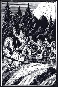
The main supply route was now by sea to Ft. Vancouver, and then upriver to three main transfer depots. Fort Okanagan was the south end of the brigade route which extended as far north as Fort St.James; Fort Walla Walla was the terminus of the Snake River brigade route; and Fort Colvile was the depot for the upper Columbia and Kootenay watersheds. Trading supplies and furs were transported along these routes. For ease of handling, they were bundled into 90 lb. "pieces". Each voyageur was expected to carry one piece on long marches, or two pieces on portages. Thompson's route through Athabasca Pass was still used for the express brigades which followed it twice a year. Each spring (usually March 20th ), the York Express departed from Ft. Vancouver with mail and accounts for Company headquarters at York Factory on Hudson's Bay. The almost 4000 mile journey was completed in time to meet the annual supply ship in mid-summer. In August, the Columbia Express departed from York Factory, delivering current communications back to Ft. Vancouver in late autumn. About three and a half months were required for each trip.
In 1827, the young botanist David Douglas joined the York Express, then under the leadership of Edward Ermatinger. Having arrived at the mouth of the Columbia in April 1825, Douglas had spent the next two years wandering around the lower Columbia and following the coast as far as southern Oregon. On many of these journeys, his only companion was his faithful dog, Billy. Wherever he went, Douglas would collect specimens of not only plants, but also new species of animals. He had learned to endure many privations and to make great sacrifices for the sake of his beloved collection. Now, he was homeward bound. He had left Ft. Vancouver with the regular Hudson's Bay Co. annual upriver express on March 20th , and a month later finds him on our door step. His journal documents the ardors of the uphill passage:
 "Friday,[April]
20th .- Slight frost in the morning. The tent being wet and partly
covered with snow from the preceding night, a small fire had to be kindled in it
before it could be folded. Passed, about a mile above our camp, McGillivray's or
Cootanie River, also a stream of some magnitude, rapid, and very clear water.
This is said to be a good route across the mountains, but from the hostile
disposition manifested by the natives inhabiting the higher parts of the
Saskatchewan, the Athabasca portage is preferred, being free from such visitors.
Five miles above it the Columbia gradually widens to a lake, one to two and a
half miles broad, some places very deep, having bold perpendicular rocks; at
other places small bays with gravelly or sandy beach with low points of wood . .
. High snowy peaks are seen in all directions raising their heads to the clouds
. . . Intended to have arranged a few words of the Chinook language, but was
molested out of my life by the men singing their boat-songs . . . Camped at dusk
on a low sandy point on the left side, four miles from the upper end of the
lake. Our distance this day is about forty-seven miles."
"Friday,[April]
20th .- Slight frost in the morning. The tent being wet and partly
covered with snow from the preceding night, a small fire had to be kindled in it
before it could be folded. Passed, about a mile above our camp, McGillivray's or
Cootanie River, also a stream of some magnitude, rapid, and very clear water.
This is said to be a good route across the mountains, but from the hostile
disposition manifested by the natives inhabiting the higher parts of the
Saskatchewan, the Athabasca portage is preferred, being free from such visitors.
Five miles above it the Columbia gradually widens to a lake, one to two and a
half miles broad, some places very deep, having bold perpendicular rocks; at
other places small bays with gravelly or sandy beach with low points of wood . .
. High snowy peaks are seen in all directions raising their heads to the clouds
. . . Intended to have arranged a few words of the Chinook language, but was
molested out of my life by the men singing their boat-songs . . . Camped at dusk
on a low sandy point on the left side, four miles from the upper end of the
lake. Our distance this day is about forty-seven miles."
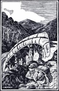
They push on and start tackling the major rapids of the Big Bend. Douglas carries his precious collections rather than to entrust them to the boats which are being lined up. On the 25th , they negotiate their way through Death Rapids. Douglas reflects on the tragedy which occurred there a decade earlier:
" All died except one, who, it is supposed on good foundation, supported his dreadful existence on a forbidden fare, having previously imbrued his hands in the blood of his companions or companion in suffering."
On Friday, the 27th , they reach Boat Encampment, cache the boats and get ready to set out on foot the following day. Douglas does a reckoning of his wanderings and concludes that he had in a little over two years traveled 7032 miles, much of it on foot. Well over 2000 miles still lie ahead.
The ascent to the pass is - as every year - a miserable business. It means crossing the freezing Wood River many times in the same day and fighting your way uphill on snowshoes, with heavy packs , through sticky, sloppy snow:
"At eleven obliged to have recourse to my bears' paws or snowshoes, the
snow 4 to 7 feet deep, being then soft by the sun's influence. Much annoyed
throughout the day by their lacing or knotting becoming slack by the wet, and
being little skilled in the use of them, now and then I was falling head over
heels, sinking one leg, stumbling with the other; they sometimes turning
backside foremost when they become entangled in the thick brushwood."
"Wednesday, 2nd .- My ankles and knees pained me so much from
exertion that my sleep was short and interrupted. Rose at 3 A.M. and had fire
kindled; thermometer 20F. Started at quarter past four. . . An hour's walking
took us to one of the head springs of the Columbia, a small lake or basin twenty
yards in diameter, circular, which divides its waters, half flowing to the
Pacific and half to the hyperborean sea."
From Athabasca Pass, the group continued walking on foot until they were met by an advance scout with 8 horses who had been sent out to meet them. They reached Jasper House two days later, at which point they again took to canoes, and after various adventures, they finally reached York Factory on Hudson Bay on August 28th where a ship was waiting. Here Douglas laments his loss of a live eagle which he had been carrying for over 2000 miles.
Douglas returned twice more to the lower Columbia; on the last trip, he planned to walk home via Alaska and Siberia in 1833. He was forced to turn back after reaching Ft. St.James and in running the Fraser lost all his collections and nearly drowned. The following year he died tragically after stumbling into a pit trap in Hawaii. He was 35 years old.
The Athabasca Pass route was followed by travelers other than those engaged in the fur trade. Hudson's Bay Company tried to encourage settlers to move to the promising farming country in the vicinity of Ft. Vancouver. Missionaries used the route to travel from Red River to the Oregon. In 1838 Fathers Blanchet and Demers led a party which left Red River on July 10th and reached Fort Vancouver on Nov. 24th Twelve of the party did not make it; they were drowned when their canoe capsized in Death Rapids. (See "Tragedy at Death Rapids"). Eight years later, Father de Smet was at Death Rapids, where he held a commemorative ceremony for the dead. At the mouth of the Kootenay, he staked out a site for a church.
Late in the same year (1846) the traveling artist Paul Kane had a narrow escape. On their westward journey, the party got delayed and entered Athabasca Pass later than normal. They were further delayed by early snows along the divide. Wood River was already choked with ice and it had to be crossed as many as 39 times in one day. They finally arrived at Boat Encampent on November 15th :
"The men had been here waiting our arrival for thirty-nine days, and would have returned to Ft. Vancouver the next day had not the guide and M'Gillveray opportunely arrived in time to prevent them, as they thought we had either been cut off by the Indians, or that we had found it impossible to cross the mountains. In fact, they were clearing the snow off the boats preparatory to starting. Had our messengers not arrived in time, it would most likely have proved fatal to us all, as we could not have re-crossed the mountains without provisions."
The Paul Kane party passed Castlegar on November 19th , resting for a few hours in the vicinity. The artist retraced his steps the following autumn, passing Castlegar on a rainy September 25th , a day after he had shot the biggest wolf he had ever seen as it was swimming in the river. At Boat Encampment the voyageurs prepared a "lobstick" for him : a tall pine was cleared of branches as high as possible and he was invited to engrave his name. In 1934, a trapper re-discovered this tree with the inscription "P. Kane, Oct.12, 1847"still clearly legible; it was removed to the Provincial Museum.
Governor Simpson, foreseeing the establishment of the international boundary far to the north, relocated company headquarters to Ft. Victoria; similarly, Ft. Colvile was abandoned and temporarily replaced by Ft. Shepherd. The Columbia Department territory became the new political entities of Oregon and Washington Territories to the south of the border, and to the north, Vancouver Island, and New Caledonia. The HBC brigades were soon replaced by flotillas of water craft using the river as an easy way to the new gold fields in the 1850's and 60's. During the tenure of the fur company the rapids of the Columbia had claimed the lives of atleast 68 men and women, including Simpson's own daughter, Mary. She had perished along with her young husband in Death Rapids, along with 10 others of the ill-starred Blanchard party.
The rapids of the Columbia which had claimed so many lives are stilled now by the Revelstoke Dam, while Boat Encampment itself rests under 525 feet of water.